


-
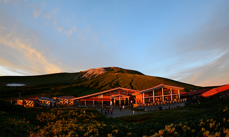
Hakusan Murodo Visitor Center in sunset

-
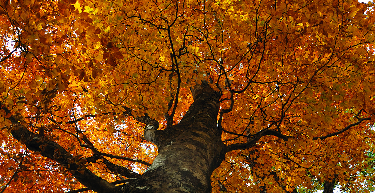
Fall foliage of Buna trees (Japanese Beech (Fagus crenata Blume))
-
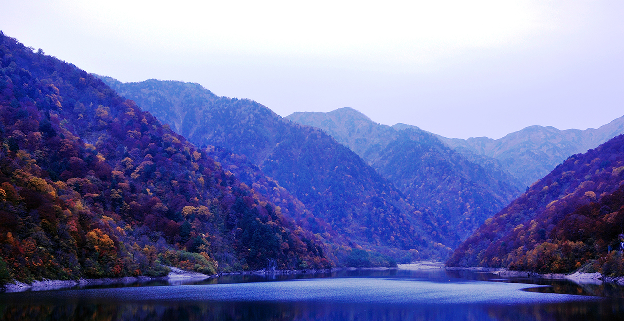
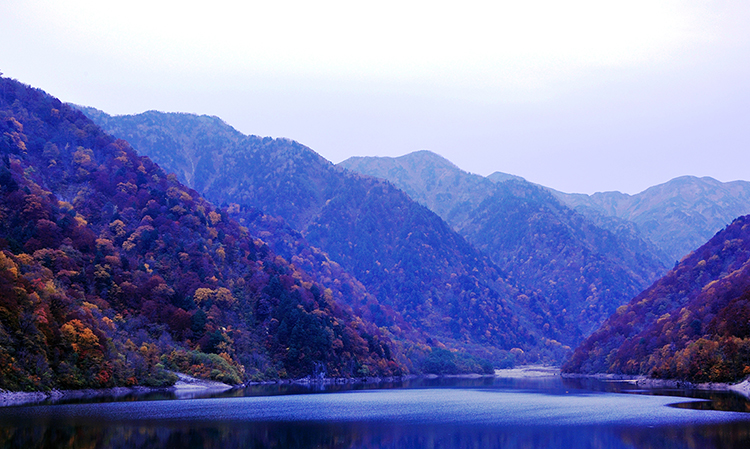
Lake Hakusui and autumn foliage
-
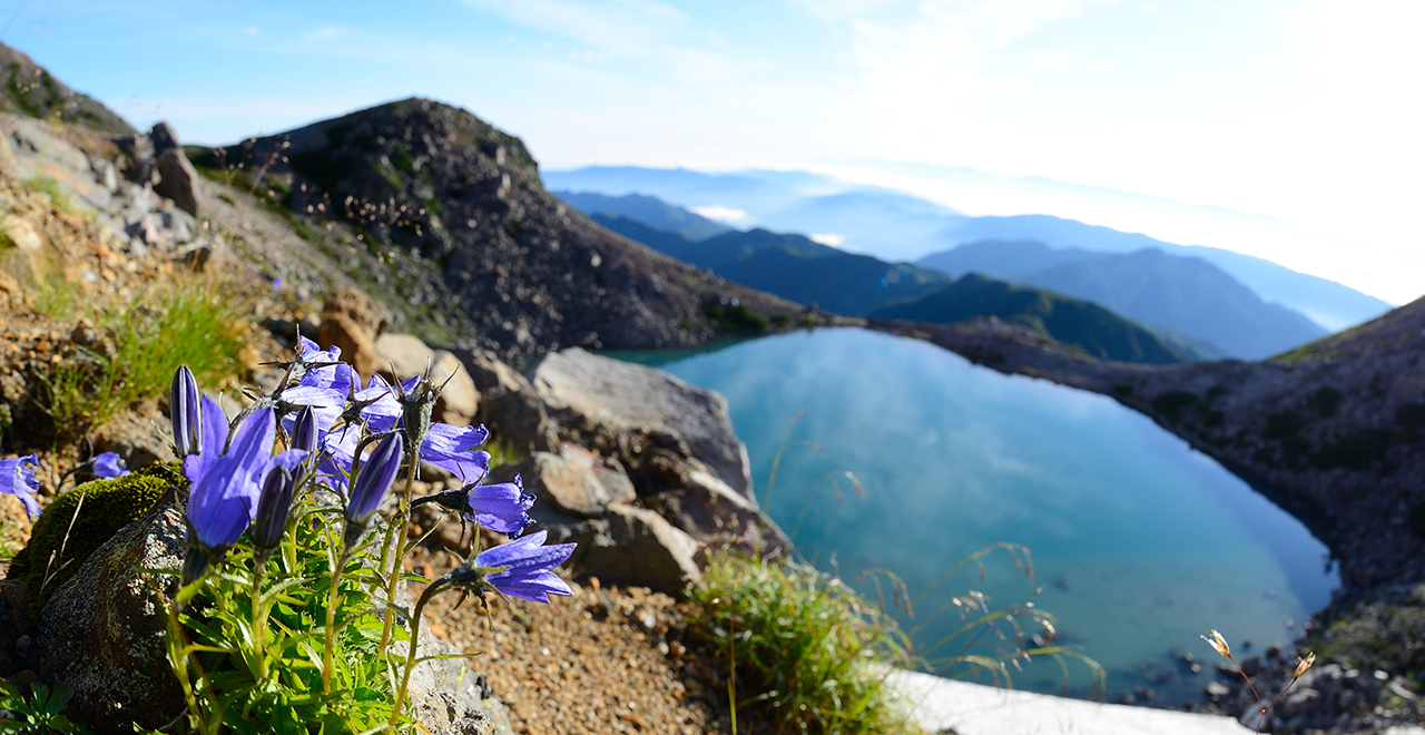
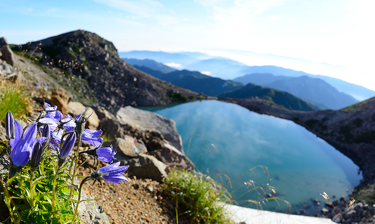
Hakusanjan (Adenophora triphylla var. hakusanensis) blooming by Midorigaike Pond
-
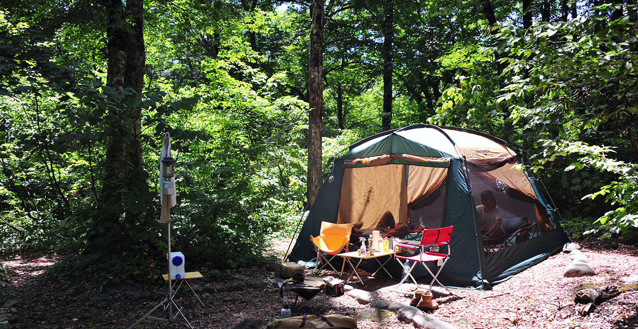
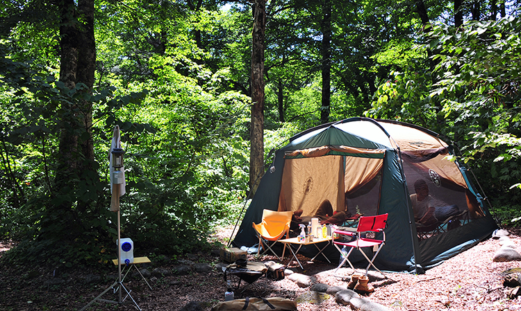
Hakusan Camping Forest Ohjirakawa
-
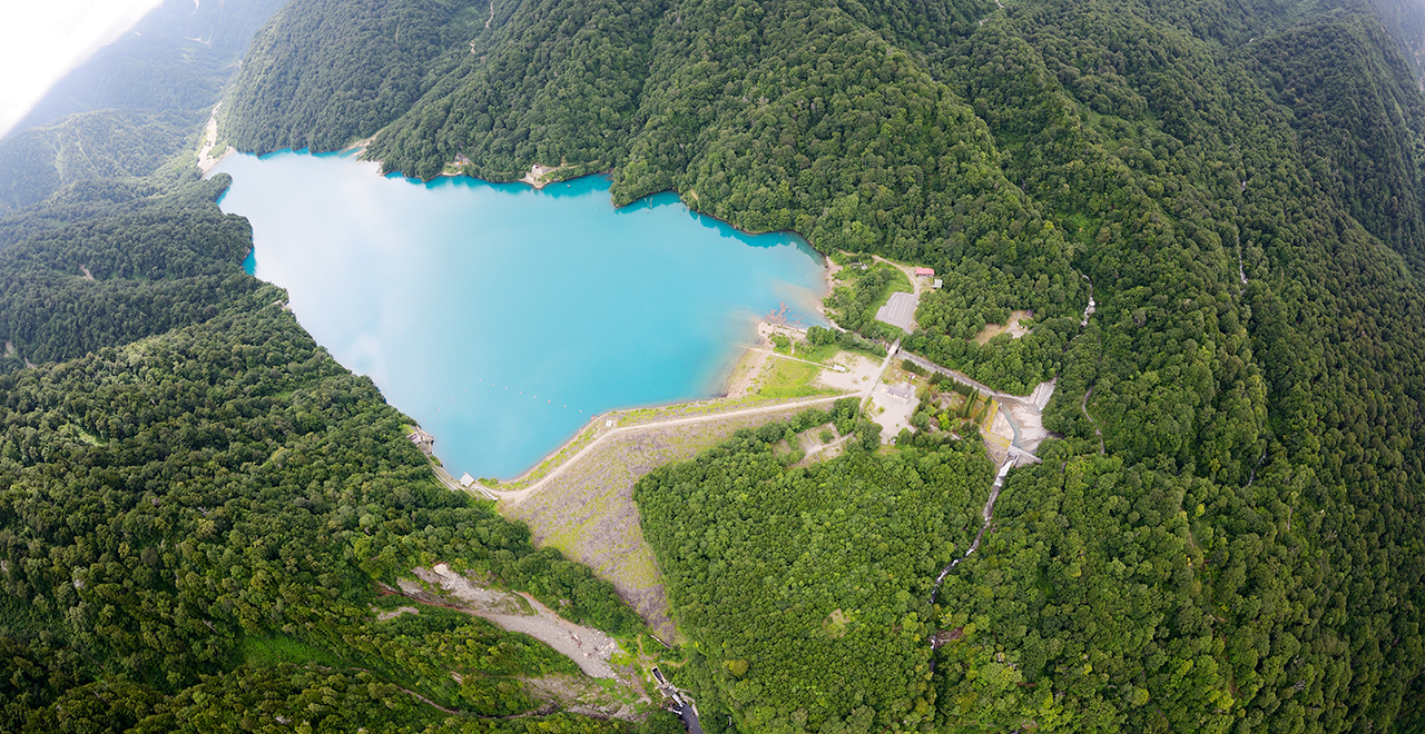
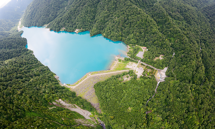
Emerald-green Lake Hakusui
Hida Hakusan Shirakawa-go Recreation Forest
2,445.33ha
Elevation Lowest : 673m / Average : 1,200–1,300m / Highest : 2,702m (Mt. Hakusan)
An extensive subalpine forest and emerald-green Lake Hakusui sitting at the foot of Mt. Hakusan
― Enjoy the great outdoors, camping, hiking, and fishing! ―
An extensive subalpine forest and emerald-green Lake Hakusui sitting at the foot of Mt. Hakusan
― Enjoy the great outdoors, camping, hiking, and fishing! ―
- Newest information
- Area
- Activities
- Overview
- Latest Information
- Usage Guide
- Facility
- Map
- Address
- Access
(Distances and times are
provided as a guide only) - Management office
contact details - Information on Other Local
Tourist Attractions - Official Tourist Information
- Recreation Forest
Management Committee - Supporters
- Other
- Newest information
- CHECK
Please visit official tourism websites for the latest updates and information.
- Area
- Chubu
- Activities
- Flower-viewing (cherry (Prunus)) Shokawa Cherry Tree (Outside the forest) Autumn leaf viewing (Includes surrounding area) Waterfall viewing Birdwatching (Includes surrounding area) Paddling / fishing (pond / lake / river) (Outside the forest) (Payment required in some cases) Bicycle rental (Outside the forest) (Multilingual signs or pamphlets available (without advance request)) Guided tours Hands-on woodworking experience (Outside the forest) (Payment required in some cases) Hot Spring (Includes surrounding area) (Multilingual signs or pamphlets available (without advance request)) Ski area (Outside the forest)
- Overview
-
- Geographical/topographical features
- The name of the Hida Hakusan Shirakawa-go Recreation Forest derives from Mt. Hakusan. It is a mountain at the center of the Ryohaku mountains lying across four prefectures: Toyama, Ishikawa, Fukui, and Gifu Prefectures. Mt. Hakusan collectively refers to multiple peaks centered on the three peaks of Mt. Hakusan, namely, the Gozengamine Peak (elevation: 2,702 m), the Onanjimine Peak (2,684 m), and the Kengamine Peak (2,677 m).
Upstream from Lake Hakusui and nestled in the Recreation Forest, ancient geological strata accumulated in the Jurassic and Cretacerous periods of the Mesozoic Era, called the Tedori sedimentary rock group, are exposed, and many fossils and dinosaur footprints have been excavated. - Historical/cultural features
- Mt. Hakusan has been a place of active mountain worship since long ago, and is counted as one of Japan's three sacred mountains.
- Climate, flora and fauna
- You can enjoy changes in the forest composition from the base of Mt. Hakusan toward its summit. Buna trees (Japanese beech (Fagus crenata Blume)) grow around an elevation of 1,400 m near the start of the Hirasedo trail (Hirase trailhead), while the forest mainly consists of Dakekamba (Erman's birch (Betula ermanii)) around an elevation of 1,500 m to 2,300 m, and Haimatsu (Siberian dwarf pine (Pinus pumila)) grow at an elevation of 2,300 m and higher.
- Attractions
- ・Shiramizu Falls: The waterfall drops 67 m and is 8 m wide. It falls like a single silk thread from a steep cliff surrounded by a virgin forest. It had been counted as one of Japan's three most beautiful waterfalls along with Nachi Falls and Kegon Falls. However, with the completion of the Oshirakawa Dam in 1963, the river water came to be taken upstream of the waterfall, and the waterfall has appeared only during the tourist season from spring through autumn ever since. Because of this, it is called a "Phantom Beautiful Waterfall" and has not been included even in Japan's 100 selected waterfalls. It is also called "Shiramizu Falls" (literally, a waterfall of white water) due to the milky white appearance of the falling water, and this is believed to have been the origin of the name "Shirakawa-go."
・Lake Hakusui: This lake was formed in 1963 by damming Oshira River flowing from Mt. Hakusan. The rockfill dam is capable of storing up to 14 million tons of water, and the surface of the lake shines emerald-green due to the components of several hot springs welling from the bottom of the lake. Lake Hakusui is located at the start of the Hirasedo trail of Mt. Hakusan. You can see glimpses of the shining lake from the steep mountain trail, showing various colors and expressions depending on the weather and the viewing location. The view of the lake refreshes hikers in their challenging steep ascent. In addition, there is Ojirakawa Open-air Bath, offering a magnificent view, by the lake where hikers can relax and relieve their hiking fatigue.
・Hakusan Camping Forest Ohjirakawa: The Hakusan Camping Forest Ohjirakawa, surrounded by giant Japanese beech and Nara (oak (Quercus)) trees, is one of the rare campsites in Japan that is located in the midst of a virgin forest.
・Mt. Hakusan hiking: Mt. Hakusan has been a sacred mountain from old times, and it can be hiked from various mountain trails in Toyama, Ishikawa, Fukui, and Gifu Prefectures. At the summit, there are several ponds, and mountain trails for walking around the ponds.
- Latest Information
-
- Regular events
- Opening of Mt. Hakusan to climbers (June), Doburoku Festival (September to October)
- Warnings (Flora and fauna)
- Asian black bear: Tsukinowaguma (Asian black bear (Ursus thibetanus)) may be present during the period from May to November. When entering the forest, please carry a bear bell and stay in a group. Check for local information on bear sightings and warnings and follow instructions.
- Usage Guide
-
- Entrance fee
- Free of charge
- Opening seasons and hours
- Accessible 24 hours a day. However, the forest is not accessible during the winter (November through May) as Pref. Route 451 (Mt. Hakusan Park Line) will be closed to traffic.
- Staffed facilities such as administration buildings
- ・Hakusan Camping Forest Ohjirakawa
・Hakusan Lakeside Lodge, Ojirakawa Open-air Bath - Accommodation options
- [Inside the forest] Hakusan Camping Forest Ohjirakawa (reservation required), Hakusan Lakeside Lodge
[Outside the forest] Hirase Hot Spring, Ogi-machi gassho-style village
- Facility
- Toilets : Hakusan Lakeside Lodge (Donation requested) Toilet (accessible) Footpath / walking trail / nature trail Parking lot : Shiramizu Falls, Hakusan Lakeside Lodge Observation platform : Shiramizu Falls Visitor center (staffed only) : Hakusan Camping Forest Ohjirakawa (Payment required for use of facilities and participation in activities) Shop (Outside the forest) Restaurant (Outside the forest) Campsite and/or cabins (Payment required for use of facilities and participation in activities) : Hakusan Camping Forest Ohjirakawa (Inside the forest), Sakurakaido Shirakawa-go Hirase Hot Spring Camp Site (In the vicinity) Free public wireless LAN (Wi-Fi) (Outside the forest) Resource center (Outside the forest) (Payment required for use of facilities and participation in activities) (Multilingual signs or pamphlets available (without advance request)) World Heritage Site / Cultural asset (nationally designated) (Outside the forest) (Payment required for use of facilities and participation in activities) (Multilingual signs or pamphlets available (without advance request)) Accommodation facilities (Hotels/Japanese inns) (Outside the forest) (Multilingual signs or pamphlets available (without advance request))
- Map
- Address
- Hirase, Shirakawa Village, Ono County, Gifu Prefecture
- Access
(Distances and times are provided as a guide only) -
- By Expressway
-
<Access>
- Tohkai-Hokuriku Expressway (Shirakawago IC) → (public road: about 50 minutes) → Hida Hakusan Shirakawa-go Recreation Forest
- ・Traffic control : Pref. Route 451 (Mt. Hakusan Park Line) may become subject to traffic control due to heavy rain or construction work. Please see the website below to check in advance.
- ・Information on construction work: "Road Information" on the website of the Road Maintenance Section of Gifu Prefecture (Available in Japanese only)
- http://douro.pref.gifu.lg.jp/Road_Maintenance/kisei.asp
- ・Information on rainfall: "Disaster Information for Rivers, Telemeter Rainfall, Hirase" on the website of the Ministry of Land, Infrastructure, Transport and Tourism (Available in Japanese only)
- http://www.river.go.jp/kawabou/ipRainKobetu.do?init=init&obsrvId=2155500100035&gamenId=01-1001&timeType=60&requestType=1&fldCtlParty=no
<Car parking capacity / parking charges>・Hakusan Camping Forest Ohjirakawa: Parking for approximately 10 vehicles
・Ojirakawa Open-air Bath: Parking for approximately 40 vehicles
・Shiramizu Falls: Parking for approximately 20 vehicles - Nearby tourist facilities
-
- Ogi-machi gassho-style village
- Management office contact details
-
Hida District Forest OfficeTEL:0577-32-0101
https://www.rinya.maff.go.jp/chubu/hida/index.html
- Information on Other Local Tourist Attractions
- ー
- Official Tourist Information
-
Shirakawa Municipal Office [External link]TEL:05769-6-1311
http://shirakawa-go.org/
- Recreation Forest Management Committee
-
Secretariat of the Hida Hakusan Shirakawa-go Recreation Forest Management Committee,
Tourism Promotion Division, Shirakawa Municipal OfficeTEL:05769-6-1311
FAX:05769-6-1709
- Supporters
- ー
- Other
- ー
PDF形式のファイルをご覧いただく場合には、Adobe Readerが必要です。
Adobe Readerをお持ちでない方は、バナーのリンク先からダウンロードしてください。
![]()