


-
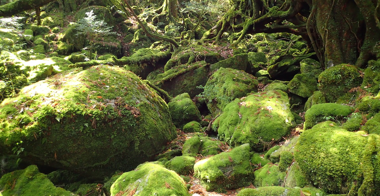
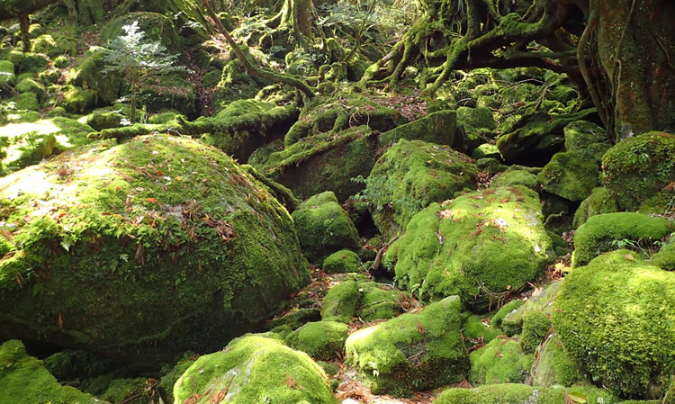
Mysterious moss forest
-
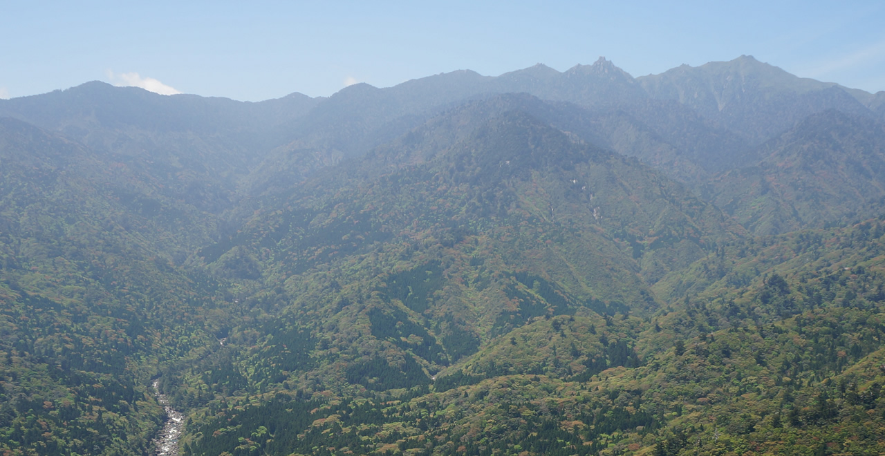
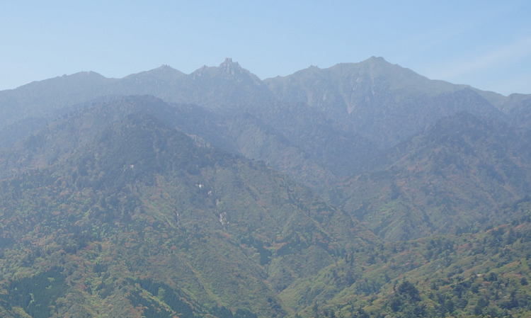
Mount Miyanoura, Kyushu’s highest peak
-
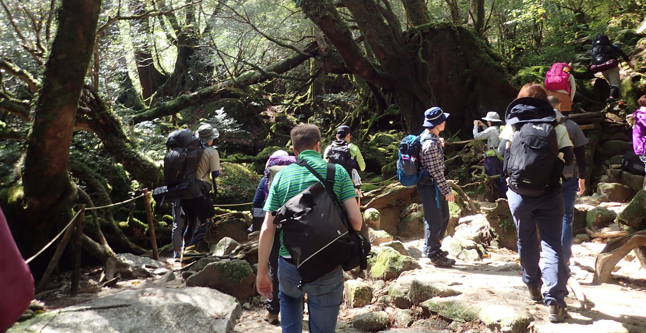
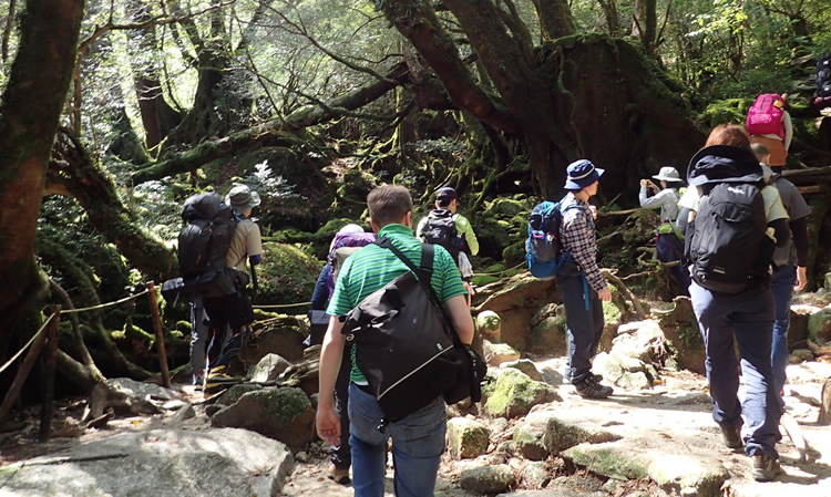
Climber enjoying Moss forest
-
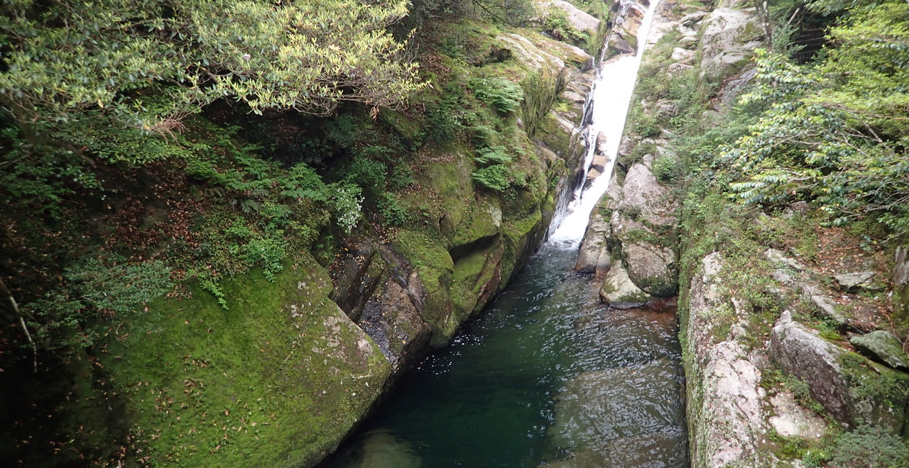
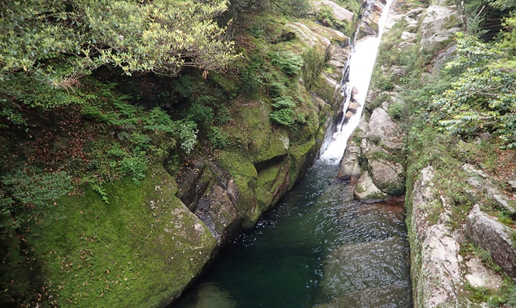
Hiryuotoshi waterfall
-
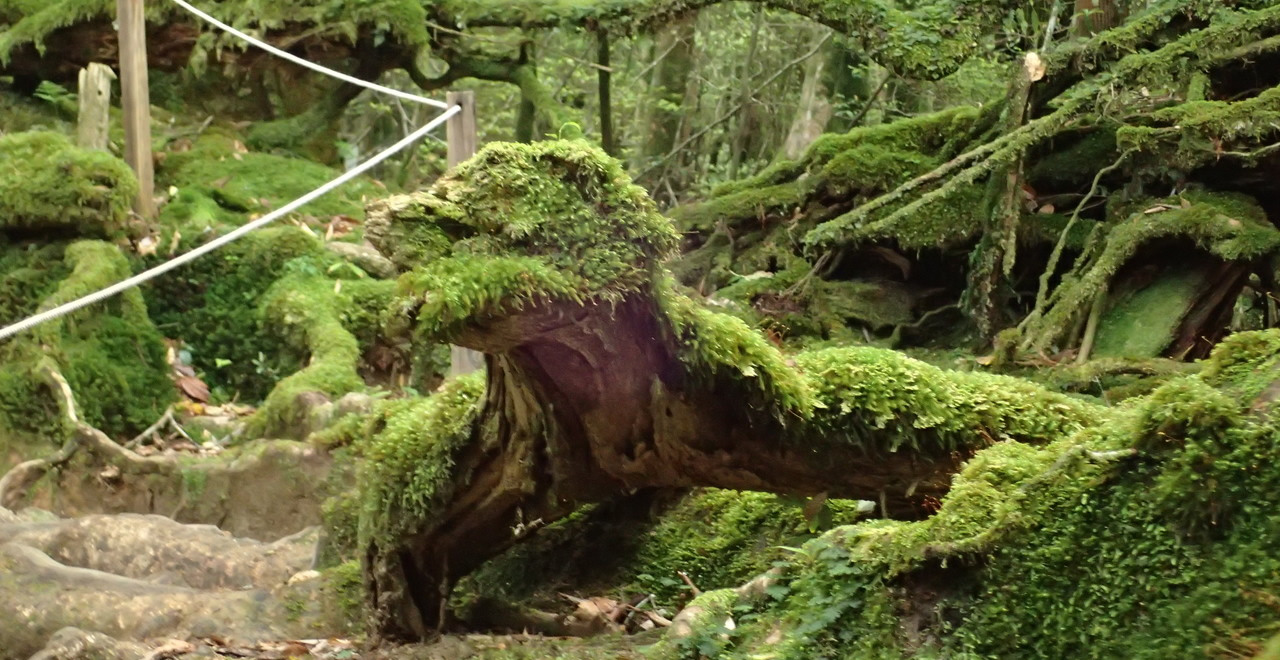
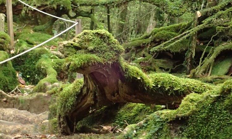
Moss Dragon?
Yakushima Recreation Forest (Shiratani Area)
426.52ha
Elevation point: 600m / Mainly 600–800m / Highest point: 1,050m
Come face-to-face with the history of an ancient forest
as embodied by the Yakusugi cedars at this World Natural Heritage Site
Come face-to-face with the history of an ancient forest as embodied by the Yakusugi cedars at this World Natural Heritage Site
- Newest information
- Area
- Activities
- Overview
- Latest Information
- Usage Guide
- Facility
- Map
- Address
- Access
(Distances and times are
provided as a guide only) - Management office
contact details - Information on Other Local
Tourist Attractions - Official Tourist Information
- Recreation Forest
Management Committee - Supporters
- Other
- Newest information
- Gathering information in advance is important to safely enjoy forest recreation that brings you closer to nature.
・CHECK
・When you go out, please check local tourist and related information and gather information on road closures, weather conditions, etc.
- Area
- Kyushu
- Activities
- Flower-viewing Waterfall viewing Birdwatching Guided tours (including areas outside the forest)
- Overview
-
- Geographical/topographical features
- Yakushima is characterized by its unique topography formed by the uplift of granite and its diverse climate.In the center of the island are a series of mountains, the main peak of which is Mount Miyanoura (1936 m), the highest peak in Kyushu, and numerous rivers carve deep valleys through the mountainsides.The Shiratani Area is a Recreation Forest located about 12 km from Miyanoura, at an elevation of 600-1050 m in the northeastern part of the island.The fantastic natural environment includes gorges formed by granite rocks, waterfalls of all sizes, mixed views of Yakusugi cedar and evergreen broadleaf forest, and a “mossy forest” covered with ferns and mosses.
- Historical/cultural features
- Visitors can see the remains of trial felling and the huge stumps of Yakusugi cedars felled to produce the flat timber (used as roofing material for wooden buildings) paid as a land tax in feudal times. In addition, there is the Kusugawa Hiking Course, which was originally developed for transporting timber out of the forest, and the remains of a lime field, which was used for growing the yamaguruma (Trochodendron aralioides) that was the basic ingredient in birdlime (a sticky substance used to trap birds and insects). Thus, this area provides an insight into the history of Yakushima's now-vanished industries.
The primeval Yakusugi cedar forest that stretches across the mountainside of Yakushima is nationally designated as a special natural monument.
The unique ecosystem and outstanding natural landscape of Yakushima were registered as a World Natural Heritage site in 1993. - Climate, flora and fauna
- Rainfall here is so plentiful that people say, “35 days’ worth of rain falls in a month.” Visitors can enjoy the splendid sight of the lichens and bryophytes that cover the earth's surface below the natural laurel forest, which includes Yakusugi cedars.
- Attractions
- Visitors can choose from three walking trails: the Taiko-iwa Rock Trail (partly following the Kusugawa Hiking Course; about 4 hours), which is the most popular; the Yayoi-sugi Trail (about 1 hour); and the Bugyo-sugi Trail (about 3 hours). Soon after entering the forest, visitors are greeted by the huge granite rock called Ikoi-no-Oiwa. If you keep the crystal-clear streams on your left and continue further onward, your eye will be caught by a huge cascade of water, called Hiryu Otoshi Falls. Various beautiful mosses cover the forest's rocks and the stumps of Yakusugi cedars felled during the Edo period, giving you the sense of being in a garden designed by Mother Nature herself. From Tsuji-toge Pass, climb a little further up to Taiko-iwa Rock to enjoy breathtaking panoramic views of Mount Miyanoura, Kyushu's highest peak, and central Yakushima's Oku-dake Mountains.
- Other
- * Due to elevation differences, each trail has hilly up-and-down sections.
* It is dangerous to attempt the walk in fashion shoes such as sandals or pumps. We recommend that you wear sports shoes or hiking boots when you visit.
* Please watch out for yamahiru, Japanese mountain leech (Haemadipsa zeylanica japonica).
* Caution is required because heavy rain can raise water levels in streams, making them impossible to cross.
- Latest Information
-
- Warnings
- ・Yamahiru, Japanese mountain leech (Haemadipsa zeylanica japonica) are present in this area throughout the year. Particular care is required in summer.
・Visitors must watch their footing on the hilly up-and-down sections of each trail.
It is dangerous to attempt the walk in fashion shoes such as sandals or pumps. Wear sports shoes or hiking boots.
Near mountain streams, there is a risk of rising water levels due to heavy rain. Avoid crossing streams unless absolutely necessary.
・The weather on Yakushima is highly changeable, due to the island's topography and other factors. Visitors must therefore make the necessary allowances in their plans, including preparing wet-weather gear and allowing for changes of schedule.
- Usage Guide
-
- Donation
- High school students and older: ¥500 per person (those who visit Shiratani Unsuikyo Ravine after visiting Yakusugi Land can use the ¥200 discount ticket that they received at Yakusugi Land)
Group discount: ¥400 per person for groups of 15 or more
Between 08: 30 and 16: 30, this donation is collected at the administration building. Outside these hours, please place your donation in the collection box provided for this purpose. - Opening seasons and hours
- Open 365 days a year May close if a severe weather warning is issued.
- Accommodation options
- There are accommodation facilities in various parts of Yakushima.
- Facility
- Toilets and drinking fountains Walking trail Parking lot Observation platform Visitor center (staffed only) World Heritage Site/Cultural Property (nationally designated) (Includes surrounding area)
- Map
- Address
- (Shiratani Unsuikyo Ravine) Miyanoura, Yakushima-cho, Kumage-gun, Kagoshima Prefecture
- Access
(Distances and times are provided as a guide only) -
- By public transport
-
<Access from nearest railway station / bus stop>
- Bus
- ・Miyanoura Port → Miyanoura / Oharamachi → Shiratani Unsuikyo (35 minutes)
- ・Anbo → Gochomae / Airport → Oharamachi (35 minutes) Change buses Oharamachi → Shiratani Unsuikyo
<Access from major transport hubs to nearest railway station / bus stop>- By air
- ・Kagoshima Airport → Yakushima Airport 30 minutes
- ・Fukuoka Airport → Yakushima Airport 1 hour
- ・Itami Airport (Osaka) → Yakushima Airport 1 hour 30 minutes
- High-speed ferry
- ・(Kagoshima Port → Miyanoura Port / Anbo Port) 2-3 hours (varies according to the route)
- Ferry
- ・(Kagoshima Port → Miyanoura Port) 4 hours
- ・Anbo Port → Anbo bus stop: 15 minutes on foot
- ・Anbo bus stop → Gochomae → Oharamachi: 35 minutes by bus
- ・Airport → Oharamachi: 20 minutes by bus
- By car
-
<Access>
- ・Miyanoura → Pref. Route 77 → Pref. Route 594 → Shiratani Unsuikyo Ravine (12 km / 25 minutes)
- ・Anbo → Pref. Route 77 → Pref. Route 594 → Shiratani Unsuikyo Ravine (28 km / 43 minutes)
<Car parking capacity / parking charges>Space for 50 vehicles (free)
- Nearby tourist facilities
-
- ・25 minutes by car from Yakushima Environmental and Cultural Village Center to Shiratani Unsuikyo Ravine
- Management office contact details
-
Yakushima Forest Ecosystem Conservation CenterTEL:0997-42-0331
https://www.rinya.maff.go.jp/kyusyu/yakusima_hozen_c/Yakushima District Forest OfficeTEL:0997-46-2111
https://www.rinya.maff.go.jp/kyusyu/yakusima/index2.html
- Information on Other Local Tourist Attractions
-
Yakushima Environmental and Cultural Village Center [External link]Yakusugi Museum [External link]
- Official Tourist Information
-
Yakushima Tourism Association [External link]Yakushima Municipal Office [External link]
- Recreation Forest Management Committee
-
Yakushima Recreation Forest Protection and Management CommitteeURL [External link]:http://y-rekumori.com/
- Supporters
-
Asahi Breweries, Ltd. [External link]https://www.asahibeer.co.jp/news/2011/sd-5/kagoshima.html
- Other
- ー
PDF形式のファイルをご覧いただく場合には、Adobe Readerが必要です。
Adobe Readerをお持ちでない方は、バナーのリンク先からダウンロードしてください。
![]()